|
|
Problems and Plans
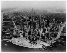
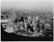
Lower Manhattan in the Sixties was a mature business district trapped in the fitments of an earlier age. A corset of finger piers bounded the island's edge, constraining growth. The downtown waterfront had been rendered obsolete, first by larger ships with deeper drafts, and from the late 1950s, by containerization which drove shipping to relocate to the vast, vacant expanses of the New Jersey lowlands. Of 51 piers, only 18 were active in 1966. The remnants of the working waterfront still exaggerated congestion, as cargo was unloaded onto the street. Elevated highways intended to improve traffic flow further segregated the public from the rivers. The reclamation and reinvention of the waterfront became a chief focus of plans for Lower Manhattan. Strategies included demolishing the decaying piers and enlarging the island, either by landfill, as at Battery Park City, or by platforming over the water, as intended, but not executed, on the East River. The low-rise, mostly 19th-century mercantile buildings that occupied the area adjacent to the piers were slated for demolition under the city's urban renewal policy. In their place, planners envisioned development zones of modern office buildings and new residential neighborhoods. The two business magnets were the World Trade Center complex and the South Ferry and Water Street district. Image Credits: |