High-Rise, High Density
Before the Wall Street Crash of late October 1929, real estate development in New York was advancing at full tilt, with skyscrapers growing in both number and scale. The Chrysler Building and 40 Wall Street were competing for the title of world’s tallest building when the announcement of the future Empire State Building surpassed them by 200 feet. Residential projects of unprecedented size were likewise erected by a few bold private developers, notably Fred French and Henry Mandel. Both men began their careers in real estate in the early 1900s constructing single buildings – first high-rise apartments, then office buildings. The key to their larger ambitions and vision was a talent for assembling large sites from many smaller lots and for securing financing for their massive projects.
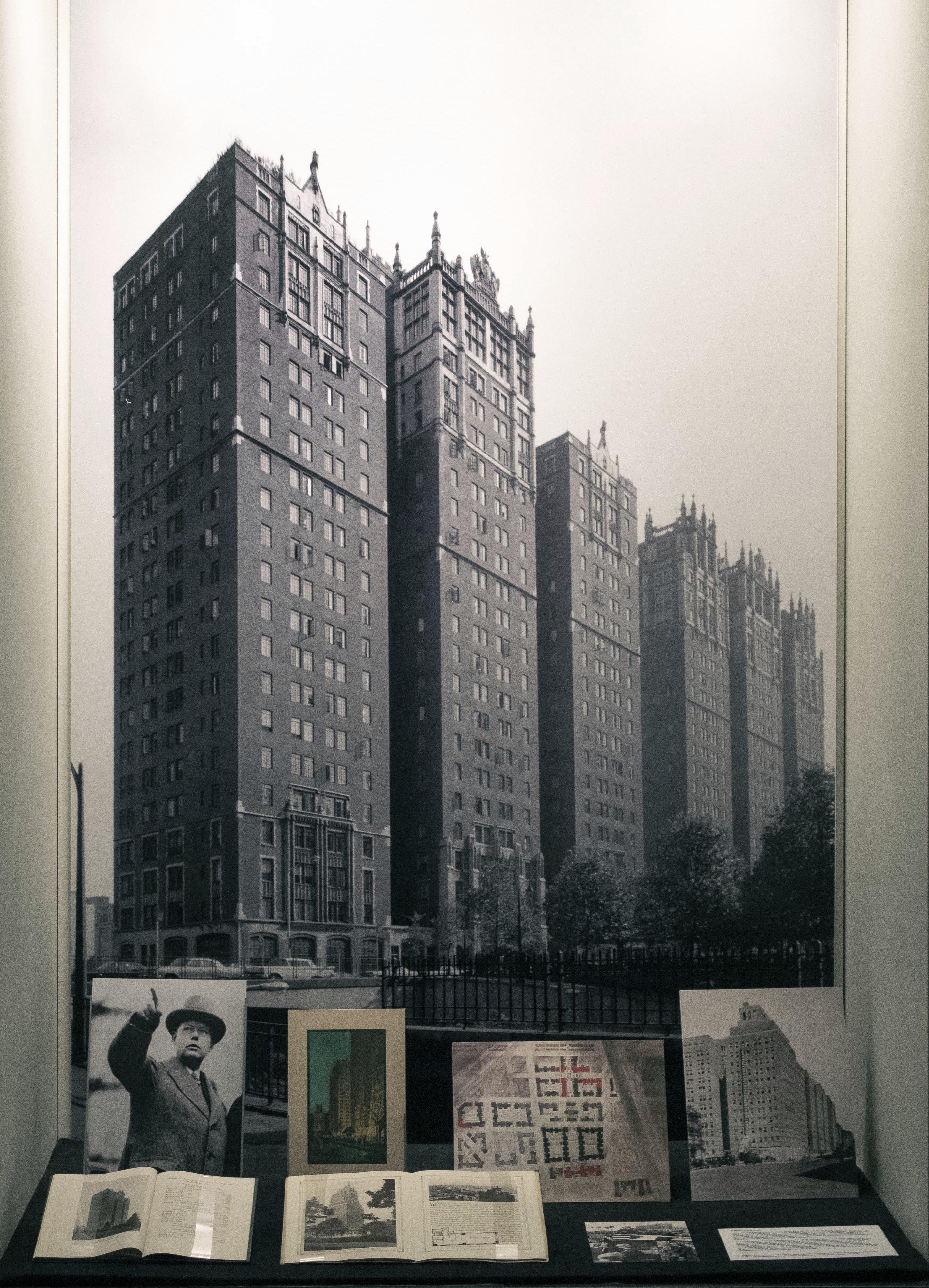
Located on the eastern end of the major crosstown thoroughfare of 42nd Street, just two avenues from Grand Central Terminal, Tudor City rose on a hilly site of nearly four city blocks occupied principally by rundown tenements that backed up at the First Avenue waterfront and a series of slaughterhouses. French’s concept was to fashion an enclave of turreted, Tudor-themed residential towers rising in a landscaped park. The small apartment units were marketed to the “average salary earner” and were made appealing by the ample open space of private gardens, amenities, and careful community controls. French called his approach to development “scientific rebuilding” and maintained that destruction was required to change the entire atmosphere of a neighborhood so it could compete with the suburbs. His vision for a new district in the city was as bold as his innovations in financing, which pioneered selling small-denomination stocks — what he called the French Plan — in his real estate company.
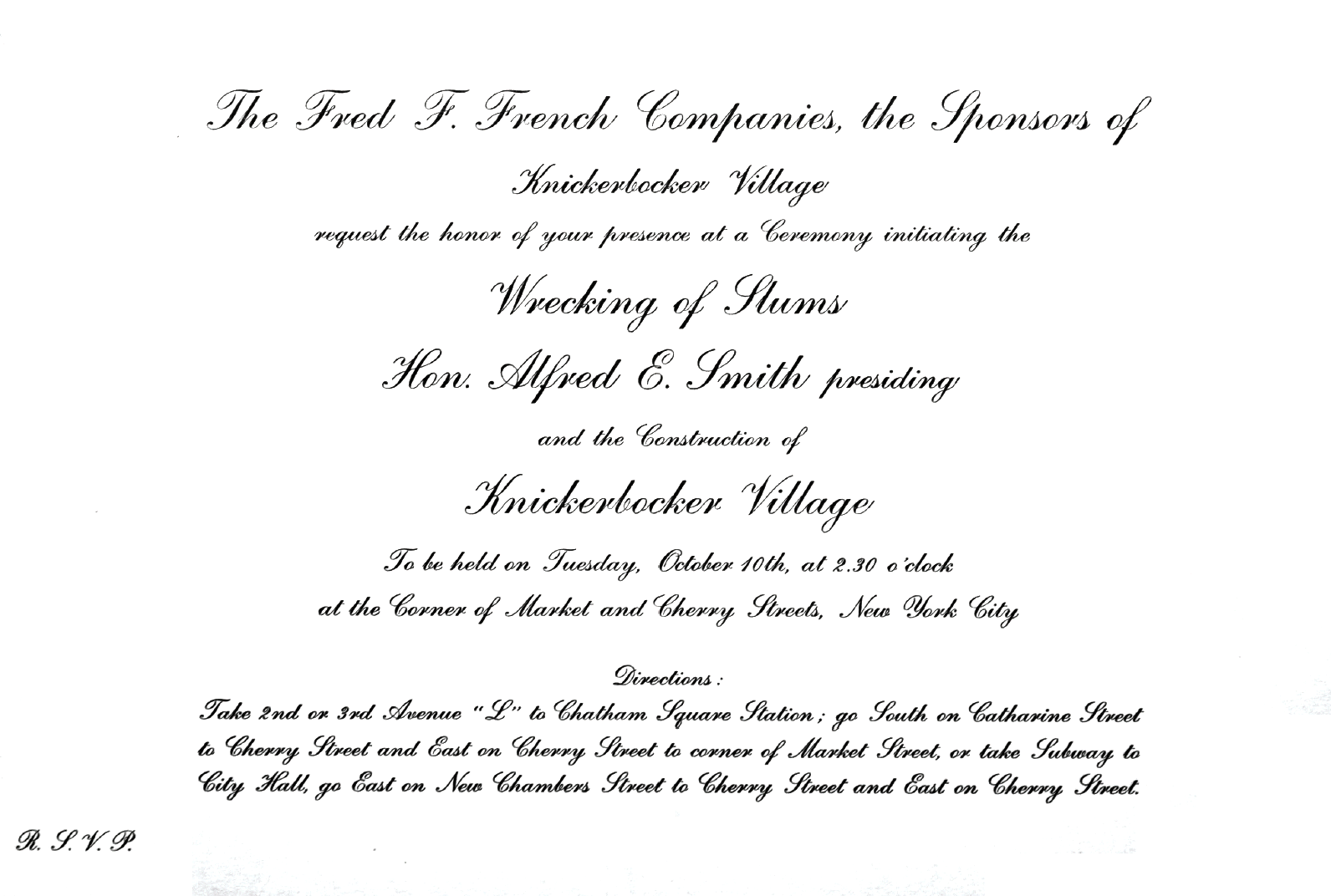
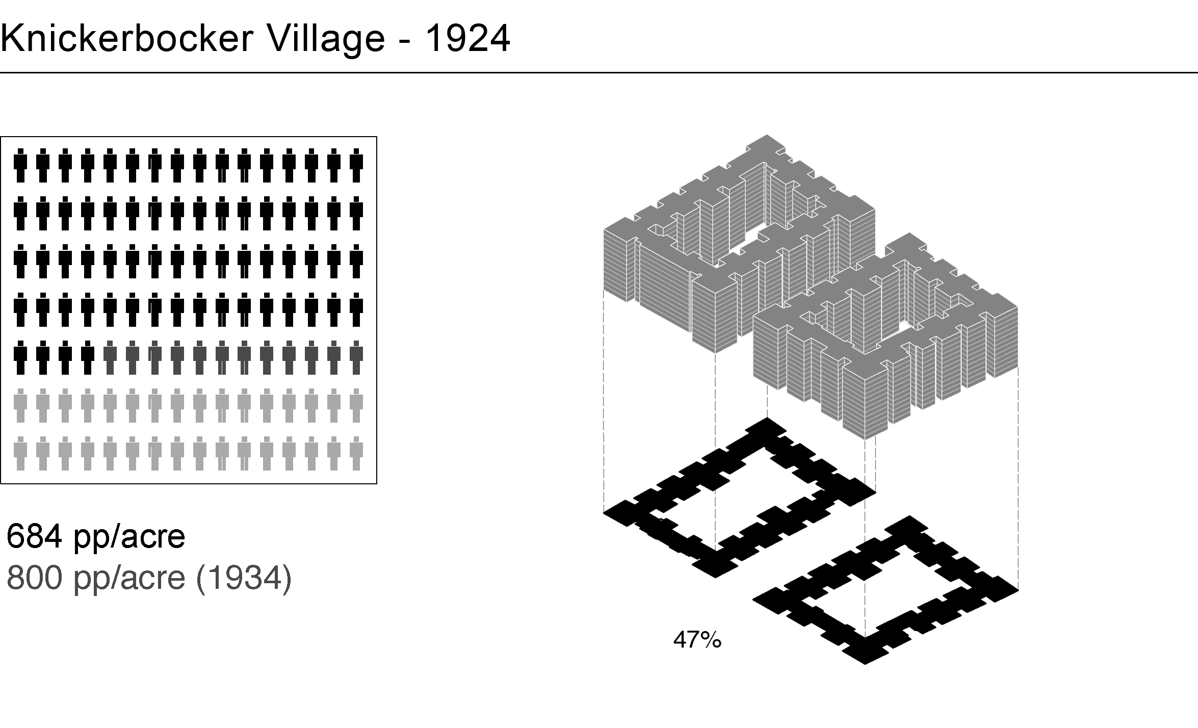
While Tudor City flourished, the perils of private-sector redevelopment emerged at French’s next major project, Knickerbocker Village, located on the Lower East Side near the Manhattan Bridge. When his plans, which included the demolition of the infamous “Lung Block,” faltered in the Depression economy, he was left holding 14.5 acres of tenement property, optioned at about $14 psf. In 1933, French went hat-in-hand to the federal government’s Reconstruction Finance Corporation to beg for millions to realize his dream. Federal officials provided only enough for part of the project: two massive perimeter blocks that, at 12 stories, rose high above the surrounding tenements, yet covered just about half the land. The project achieved a density of 800 people per acre. NYCHA’s first Chair, Langdon Post, called Knickerbocker Village “new types of slums,” but the tenants disagreed after repairs were made to the hastily-built buildings.

NYCHA, Density Reduction

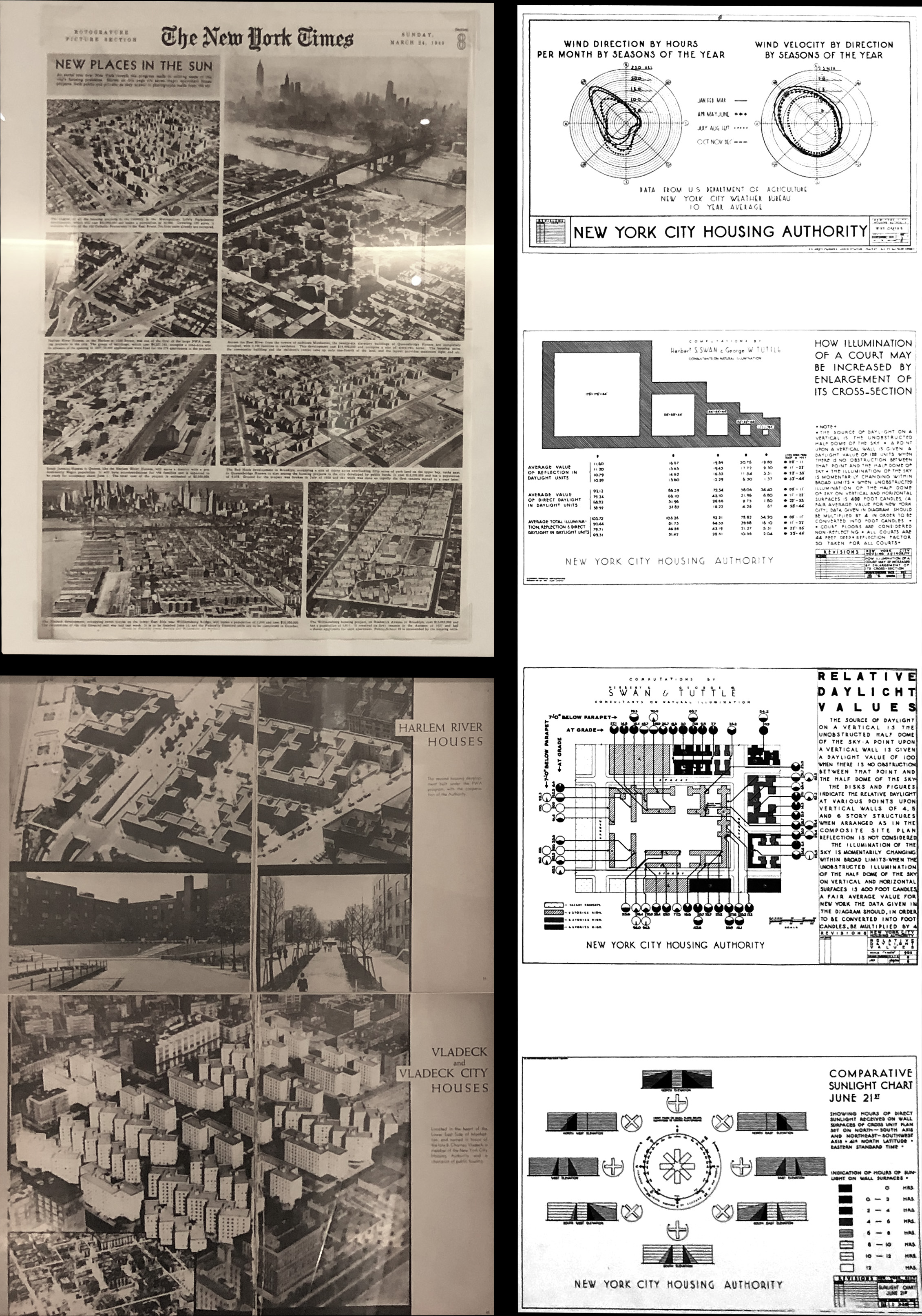
In 1934, as the Great Depression deepened, New York State established the New York City Housing Authority (NYCHA) as a vehicle for housing reformers to continue their campaign for both slum clearance and government assistance to construct housing for low-income families. Between 1934 and 1936, the authority demolished 1,100 Old Law tenements.NYCHA planners and architects evolved a program of density reduction that went far beyond any previous models. Both in number of units and use of large sites, NYCHA’s scale afforded the opportunity to adjust the various site-planning factors with the goal of maximizing open space and sunlight. This aim is one of the least-understood aspects of NYCHA’s history.
The person most responsible for NYCHA’s housing models was Frederick Ackerman, the head of the Technical Division’s staff of architects and planners. A 1937 report titled “A Note on Site & Unit Planning,” prepared by Ackerman and his assistant William F. R. Ballard, laid out site diagram scenarios of different building configurations. These explored methods to maximize openness by means of adjusting the height, open space, and cost, as shown on the rear wall. NYCHA eventually shifted from bar-buildings to Y-plan buildings, seen in the Queensbridge model, and slowly moved towards the high-rise. The ranges of land coverage and people per acre set by Ackerman in the 1930s remained, and even decreased, during the following decades.
Ackerman’s obsession with open space stemmed from his desire to provide residents more light and air, as he believed that light should be maximized at the expense of other conditions — especially population density.

Queensbridge and Stuyvesant Town
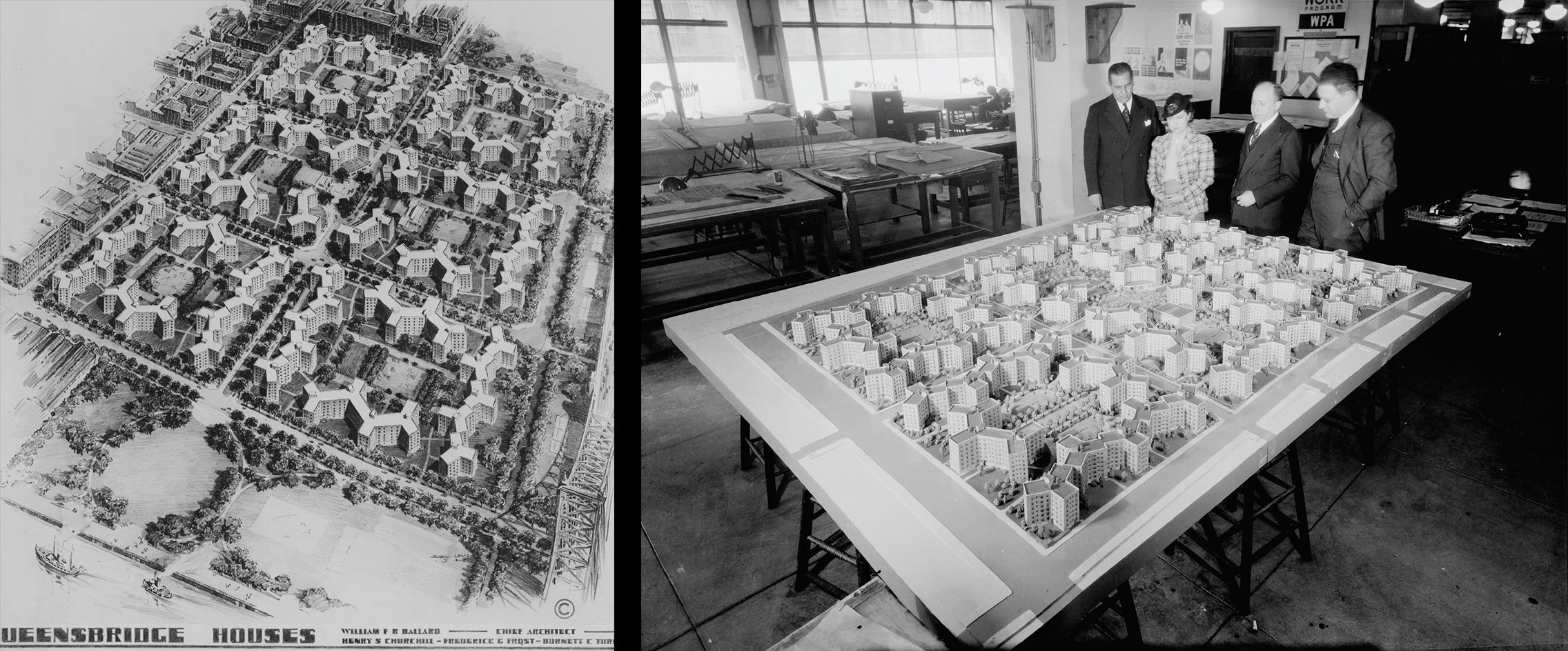
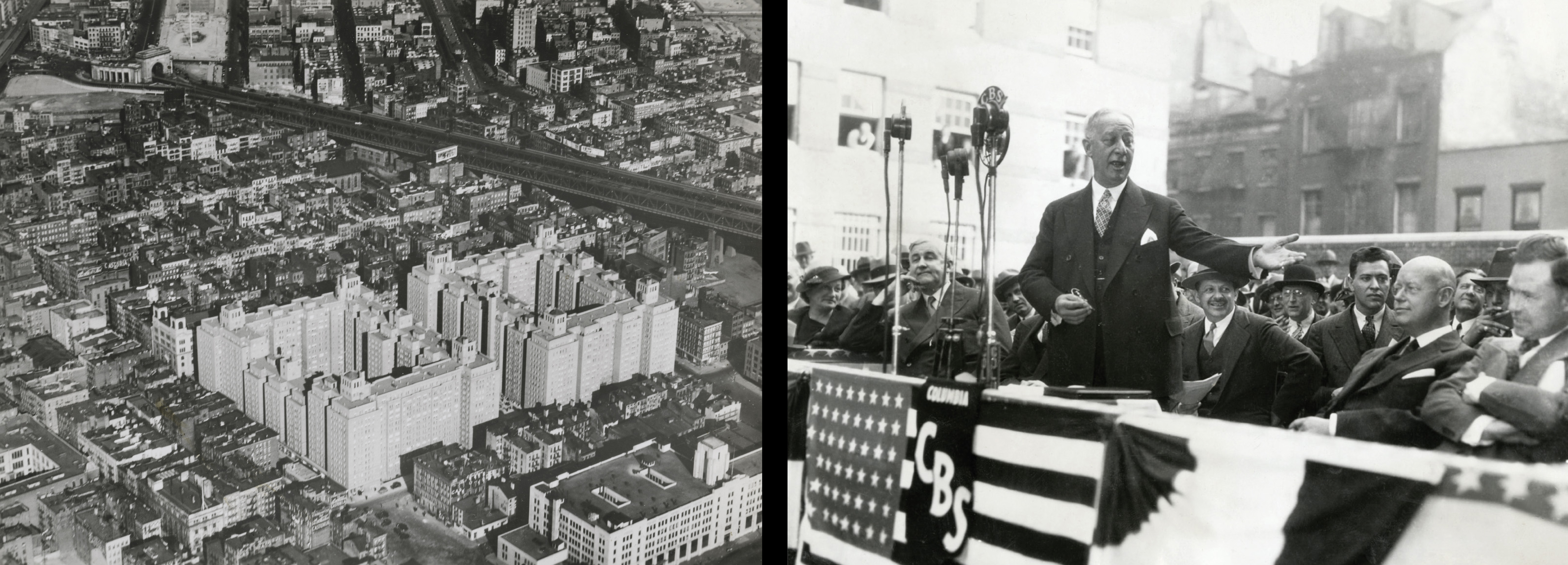
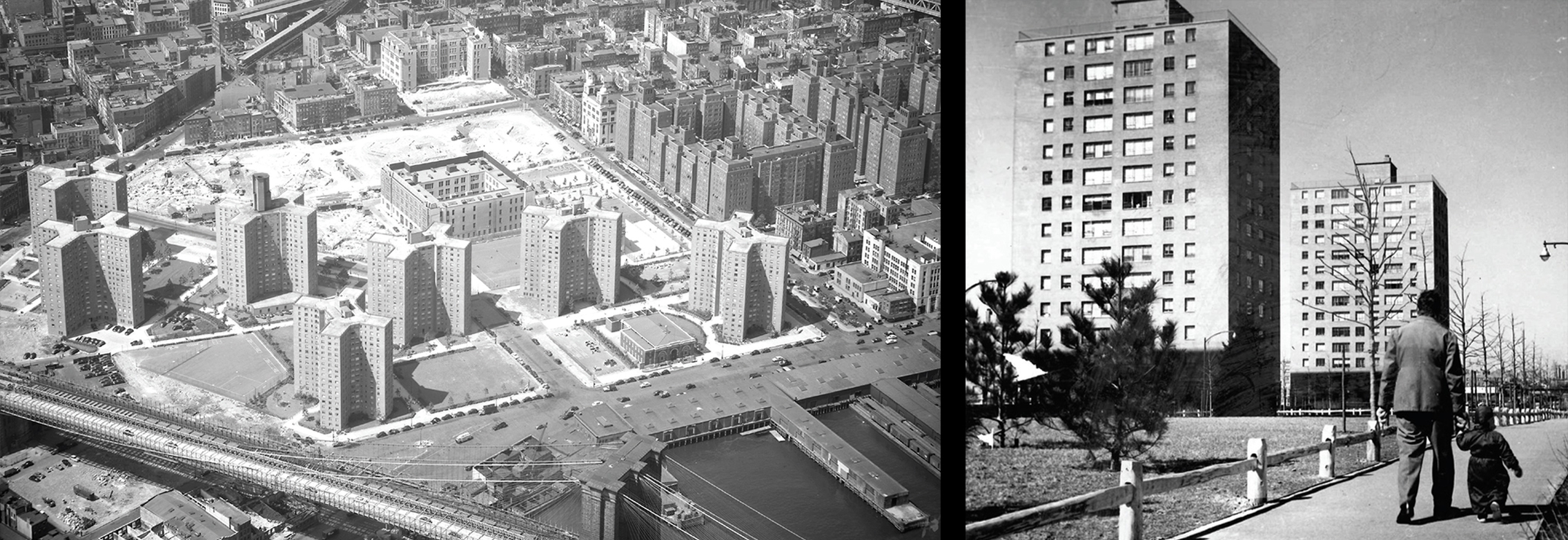
New York City’s leaders pioneered a revolutionary vision of urban living: large-scale, master-planned, high-rise, low-density, apartment communities. The success of these places—with residents, the media, and designers—set the city on a path to density reduction in the decades that followed.In public housing, NYCHA developed the vast Queensbridge Houses (26 percent land coverage and 209 pp/acre) as an efficient, self-contained mini-city for the working-class with a central shopping district and community center. The site, a former industrial area, was purchased for just $1.00 a square foot, a bargain compared to Vladeck Houses on the Lower East Side ($3.76 per square foot). Fredrick Ackerman, chief architect of NYCHA, who defined Queensbridge’s parameters, encouraged 6-story elevator buildings to reduce the cost of expensive foundations. The design team economized by repeating the same building type across the entire site. With 3,142 units, the small, but efficient apartments boasted light in every room and modern sanitary and heating facilities. The primary on-site luxuries were the acres of trees and numerous playgrounds.
When Queensbridge opened in 1939, the first tenants (mostly white), were carefully selected nuclear families who agreed to be highly supervised by nosy housing assistants who kept close track of their incomes, housekeeping, and behavior. Queensbridge’s approach to design and tenancy was imitated, usually in much taller buildings, in the NYCHA projects that followed.
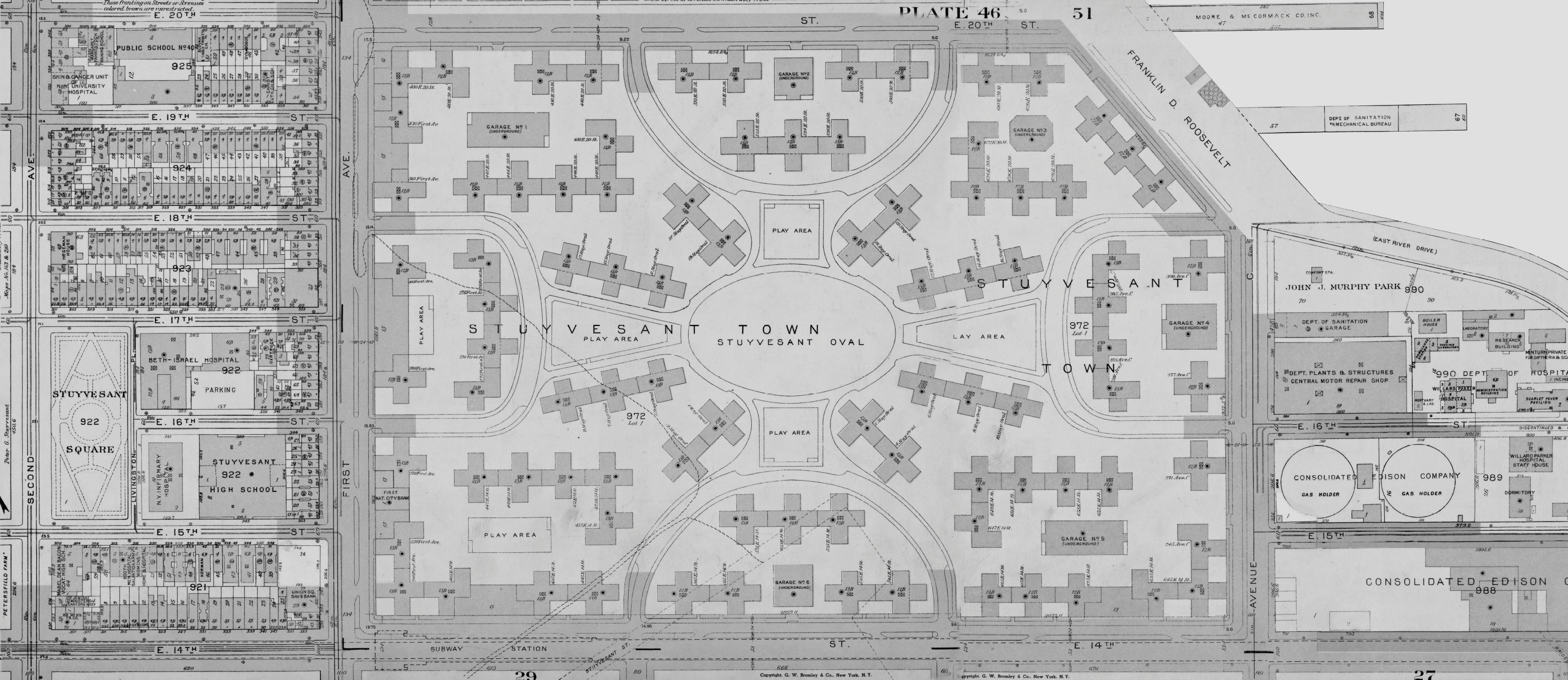
City leaders, most notably Robert Moses, also encouraged middle-class, large-scale, master-planned, low-density projects. Stuyvesant Town, developed by the private company Metropolitan Life Insurance, required a massive slum clearance program paid for largely by the city. Located between 14th and 20th streets and First Avenue to Avenue C, the 80-acre site replaced the Gas House district of gas storage tanks. Planned in 1942, the first buildings opened in 1947. The buildings of Stuyvesant Town covered only 26 percent of the site and delivered 302 pp/acre. Stacking up the 8,757 apartments in 15-story buildings failed to overcome the impact of low ground coverage. The all-white residents benefited from generous apartments, private green spaces, and neighborhood retail. Sponsors carefully managed occupancy to prevent crowding. Those families lucky enough to get apartments realized that they had gotten far more than just apartments—they were living in a new, lower density urban landscape that stood apart from the city and was secured by private police. Many would stay for decades.
Slum Clearance and Title I

The federal Title I redevelopment program of 1949 provided a powerful new tool for density reduction in postwar New York. Robert Moses, the City’s Construction Coordinator, who also dominated the Mayor’s Committee on Slum Clearance, combined eminent domain and local subsidies with generous Title 1 grants for site acquisition. The success of the Title I program depended upon participation by a mix of private and non-profit sponsors.
In the 1950s, the area south of Washington Square, today the province of the NYU campus, contained blocks of low-rent tenements and was considered a “blighted area.” It became an early target for two studies for slum clearance under the Title I program: Washington Square South and the South Village. The architectural firm Skidmore, Owings & Merrill (SOM) prepared reports shown on the rear wall: neither was built as drawn, but a large swath of tenements from LaGuardia Place to Mercer Street, north of Houston was cleared for redevelopment.
As built, Washington Square Village (1959) was a superblock project that delivered 1,292 apartments in two parallel slabs set in spacious landscaped gardens. Demand for the bright, modern units was surprisingly weak, however, so the private developers Paul Tishman and Morton S. Wolf sold the project to NYU in 1964 for graduate and faculty housing.
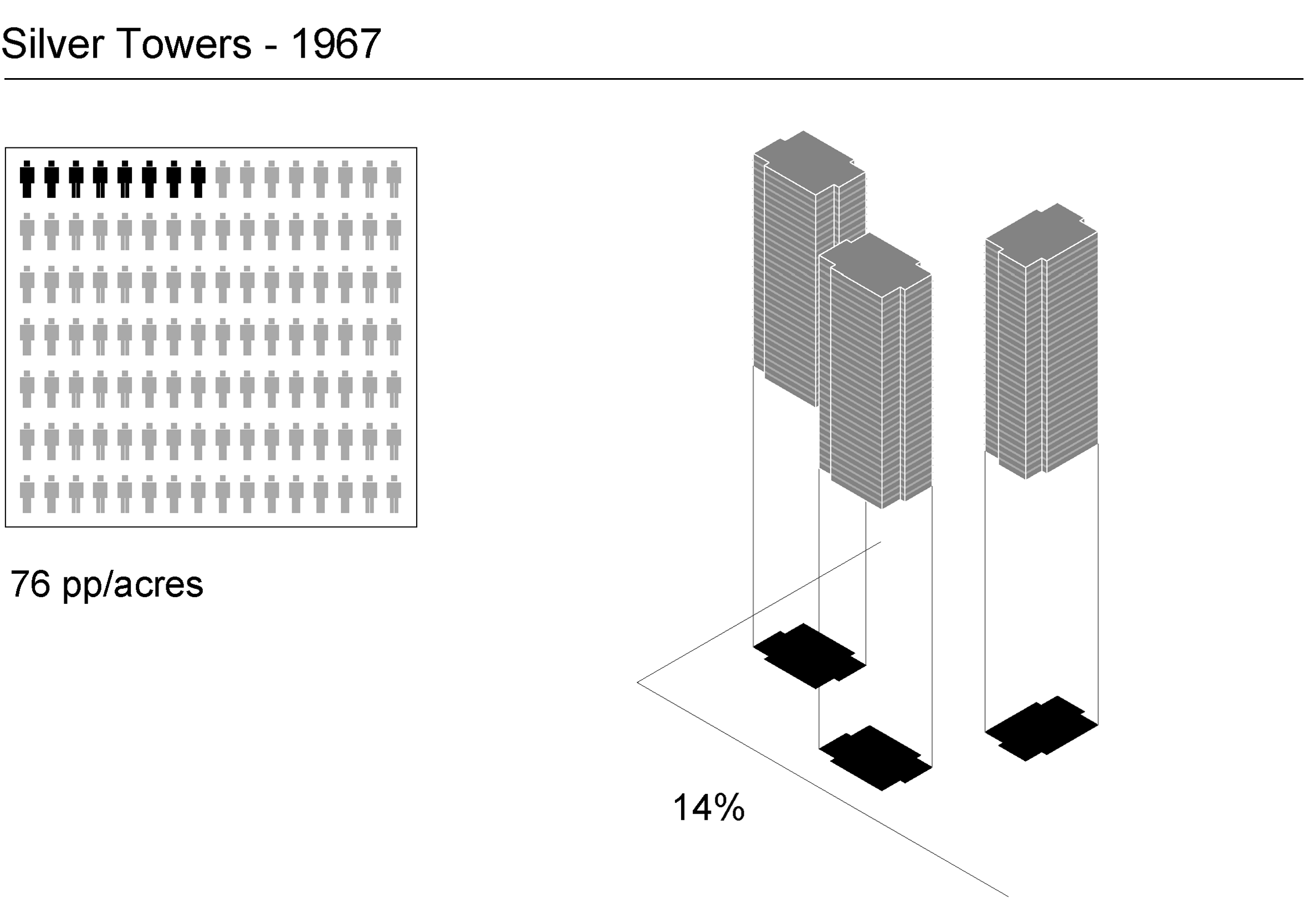
Intent on building out areas near the campus bulldozed under the Title I plan, NYU commissioned I. M. Pei Associates to design the three-building complex Silver Towers (1965) for additional university housing. The trio of 30-story concrete towers with oversized windows broke with the standardized postwar slabs and marked one of the most architecturally significant of Title I Mitchell Lama projects targeted towards middle-class residents.
The dramatic reduction of land costs made possible by government subsidies reduced pressure on developers for higher-density housing in projects like these across the city. For many years, Robert Moses received wide support from journalists, city officials, non-profit leaders, and the business community for his Title I projects.
Manhattan House
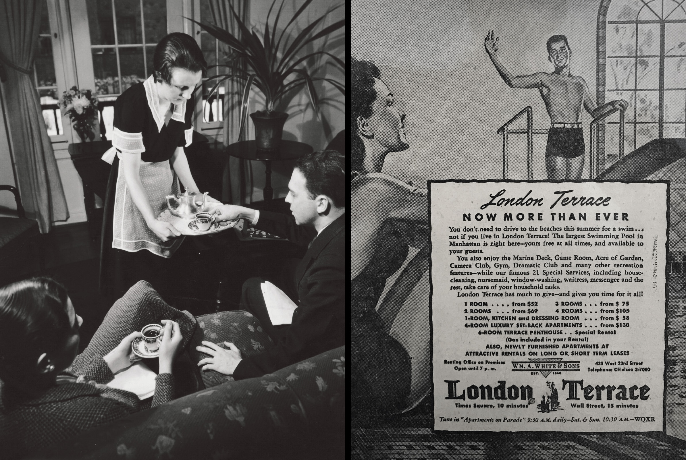
Postwar, the private sector showed signs of renewed interest in high-density housing. The resurgence of the city’s service sector, as embodied in gleaming office towers of midtown, indicated a real estate vitality not seen in the city since the 1920s. Modernist apartment projects pointed the way to stylish, in-town living that would have been familiar to Fred French, had he lived to see their development.
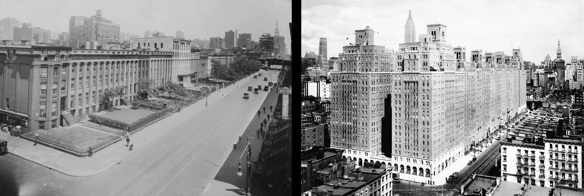
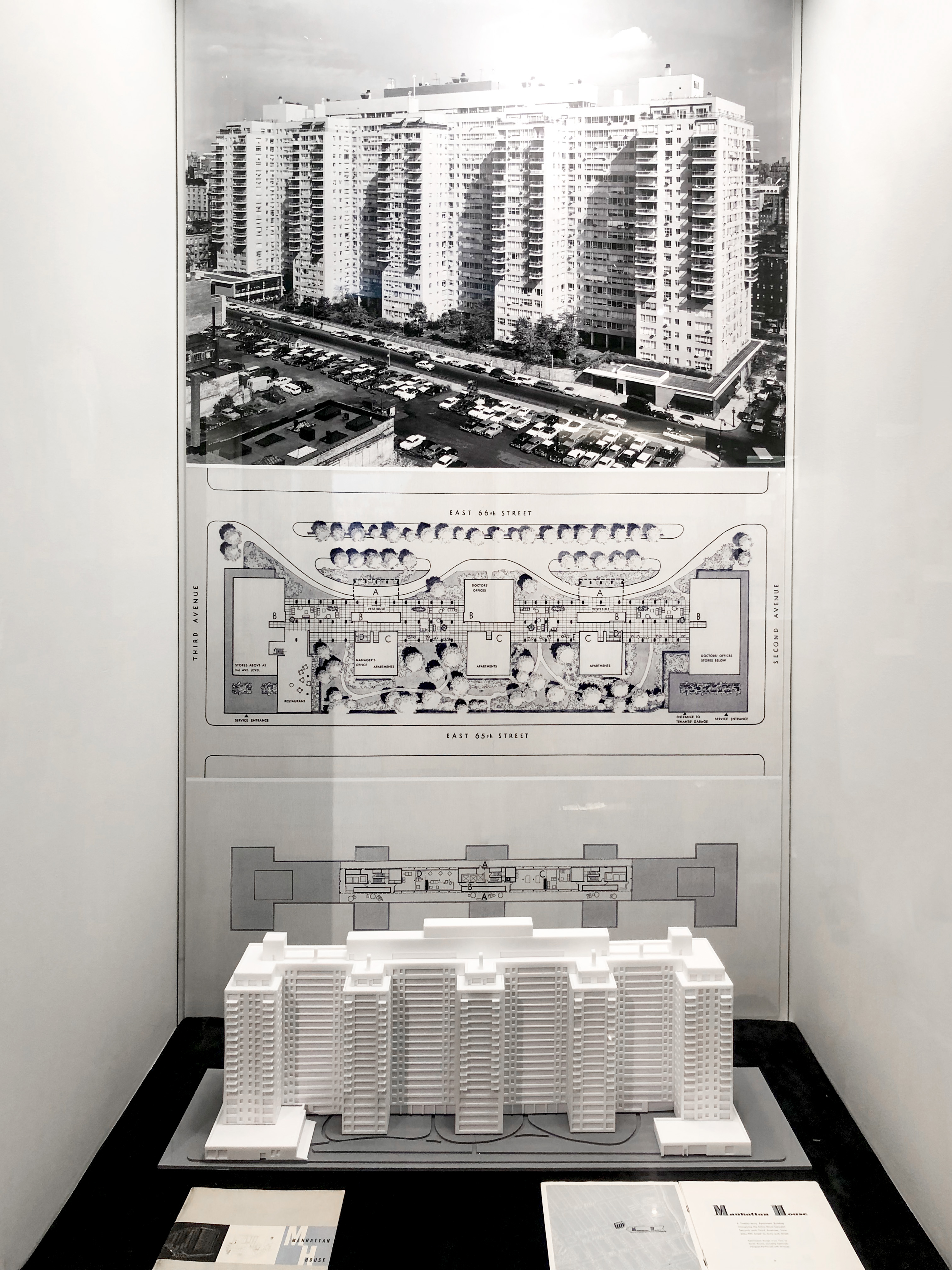
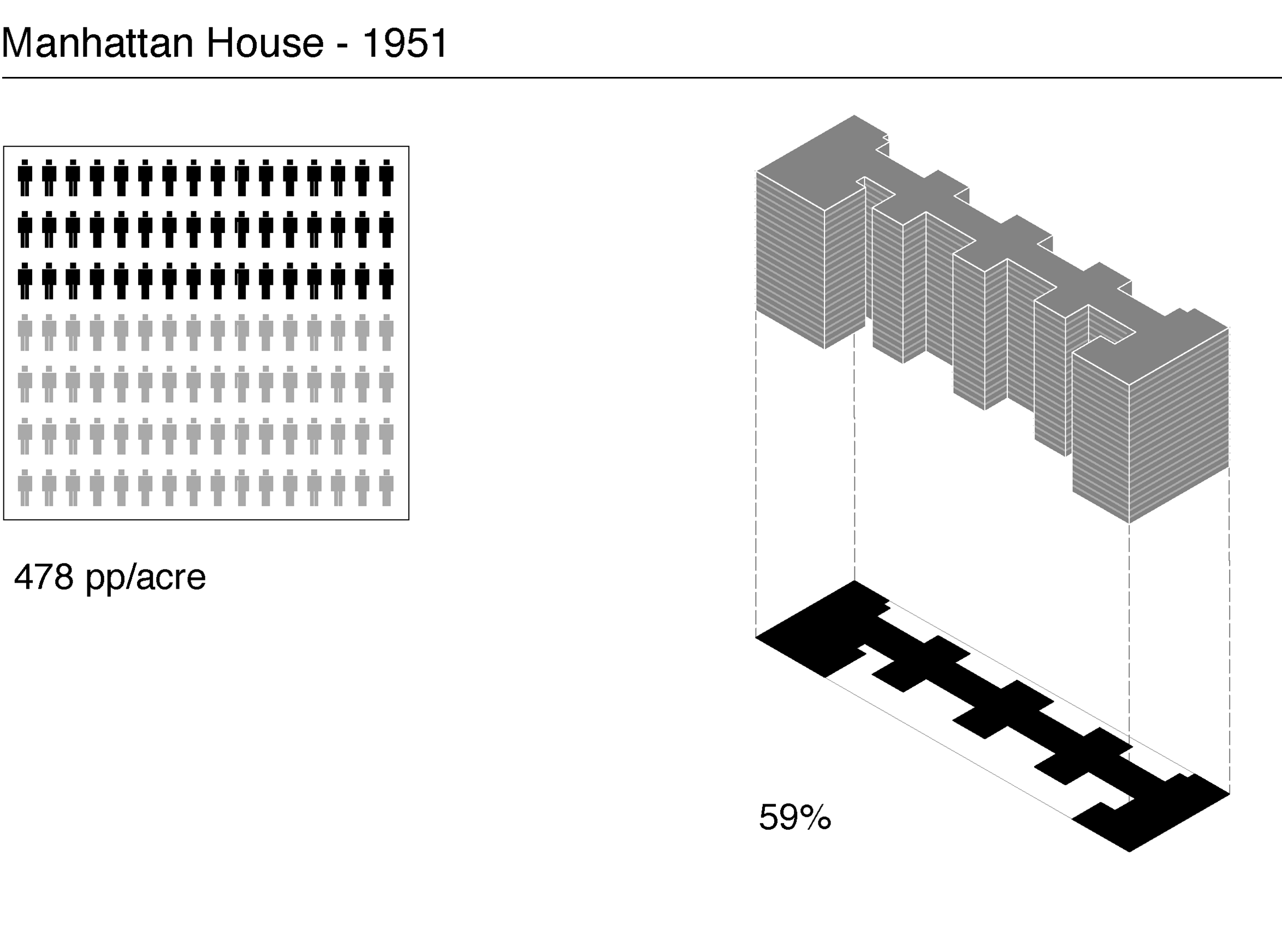
Located between 65th and 66th streets between Second and Third avenues, Manhattan House (1947-51) occupied a full block in an area that was undergoing significant change as the elevated train tracks that had imprisoned that swath of the city were either recently demolished or scheduled for demolition. An old trolley barn, tenements, and assorted commercial buildings were so affordably priced that New York Life bought extra property in the surrounding blocks.
The clean, crisp modernist design by architect Gordon Bunshaft, principal at Skidmore, Owings & Merrill (SOM), which was associated with the firm Mayer & Whittlesey on the project, was an immediate success and attracted famous tenants such as Benny Goodman, Grace Kelly, and furniture designer Florence Knoll, as well as Bunshaft himself. The apartments were spacious, but the overall density was an impressive 478 pp/acre. Thanks to New York Life’s interest in long-term profits, the building was more “tower in a garden” than “tower in the park” and covered a higher percentage of land (59 percent) than the vast publicly subsidized projects that were its contemporaries.
Manhattan House inspired its share of glazed brick imitators, but the truth about private investment in postwar New York was grim. With unrelenting middle-class flight, the demand for high-quality, higher-priced apartments in Manhattan remained comparatively weak. Density reduction, given these facts, made more sense to both private and public developers. Had density levels of Manhattan House been pursued across large areas of the city during the postwar years, it is likely that the city would already be accustomed to much greater density as is the case in crowded cities like Hong Kong. Instead, market failure in postwar New York was used to justify an aggressive strategy of subsidized low-density living.
Penn South

Labor unions were enamored with density reduction because many of their members and leaders had endured tenement crowding. Unsentimental about the old neighborhoods, they endorsed their replacement with modern, comfortable, well-located apartments. The United Housing Foundation (UHF), a consortium of labor unions led by Abraham Kazan, was a major partner in Title I and the largest sponsor, by far, of the state Mitchell Lama program. The UHF, with the help of Robert Moses and Governor Nelson Rockefeller, used low-cost mortgages, site-acquisition assistance, and other subsidies to build a social democratic vision of urban living. Apartment dwellers would manage their own housing as “cooperators.” Profits were limited and amenities for tenants compensated for other problems in a declining neighborhood.
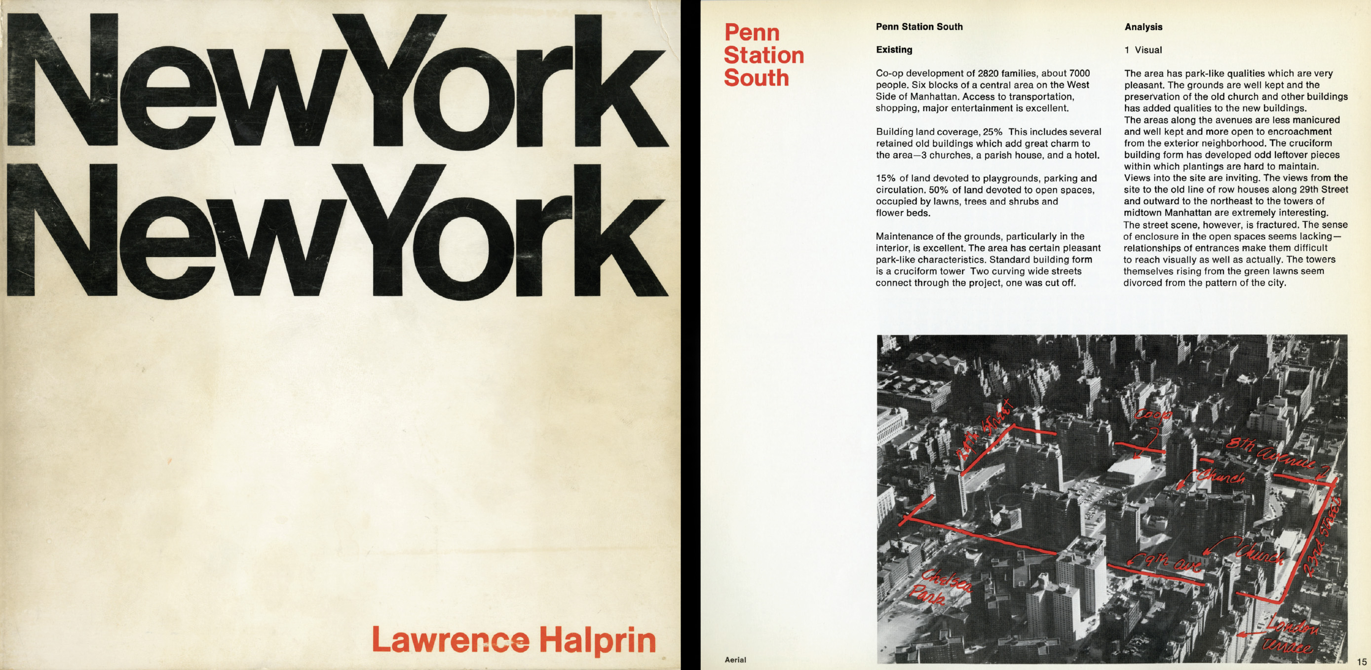
A stand-out project of this new model was Penn South, developed in 1962 as a cooperative by the UHF, on an urban renewal site stretching from West 23rd to 29th streets from Eighth to Ninth avenues. The federal government’s Title I program underwrote the project as “part of the overall plan to eliminate substandard areas in the City and create in their stead sound, permanent reuse areas for housing and community facilities.” The widely-spaced towers replaced a “blighted area” heavily built up with Old Law and New Law tenements that covered 70 to 90 percent of their lots. The land was purchased through eminent domain at the very reasonable price of $4 a square foot.
UHF in-house architect Herman Jessor laid out Penn South as a superblock offering a “unified area with long vistas of landscaped gardens.” With low land coverage of just 17 percent, the sponsor was required to go up to 20 and 21 stories to provide an average of 280 apartments per building in order to make the project economically feasible. The density level of 302 pp/acre was achieved by stacking all the families on the small built areas. The large size of the units, big balconies, and the careful control of tenancy through a cooperative management plan meant that there was little chance of overcrowding.
Yet there was a price to be paid for project development. Thousands of poor site tenants were displaced; large areas of these projects went underbuilt and remain so today; class lines sharpened between those inside and outside these communities; many cooperatives encountered management difficulties; the projects offered little or nothing in service to neighborhoods around them; and their park surroundings undermined the vitality of neighborhood commercial districts.

Towers in the Park
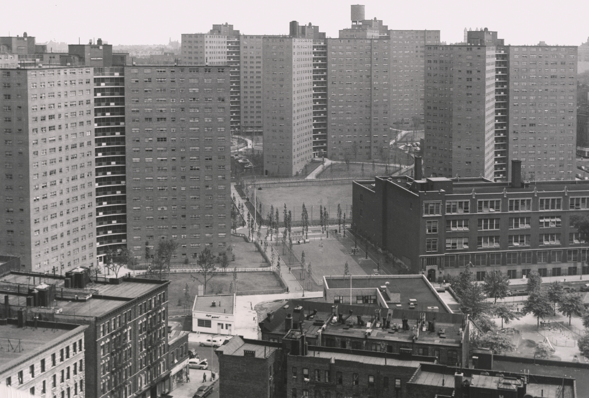
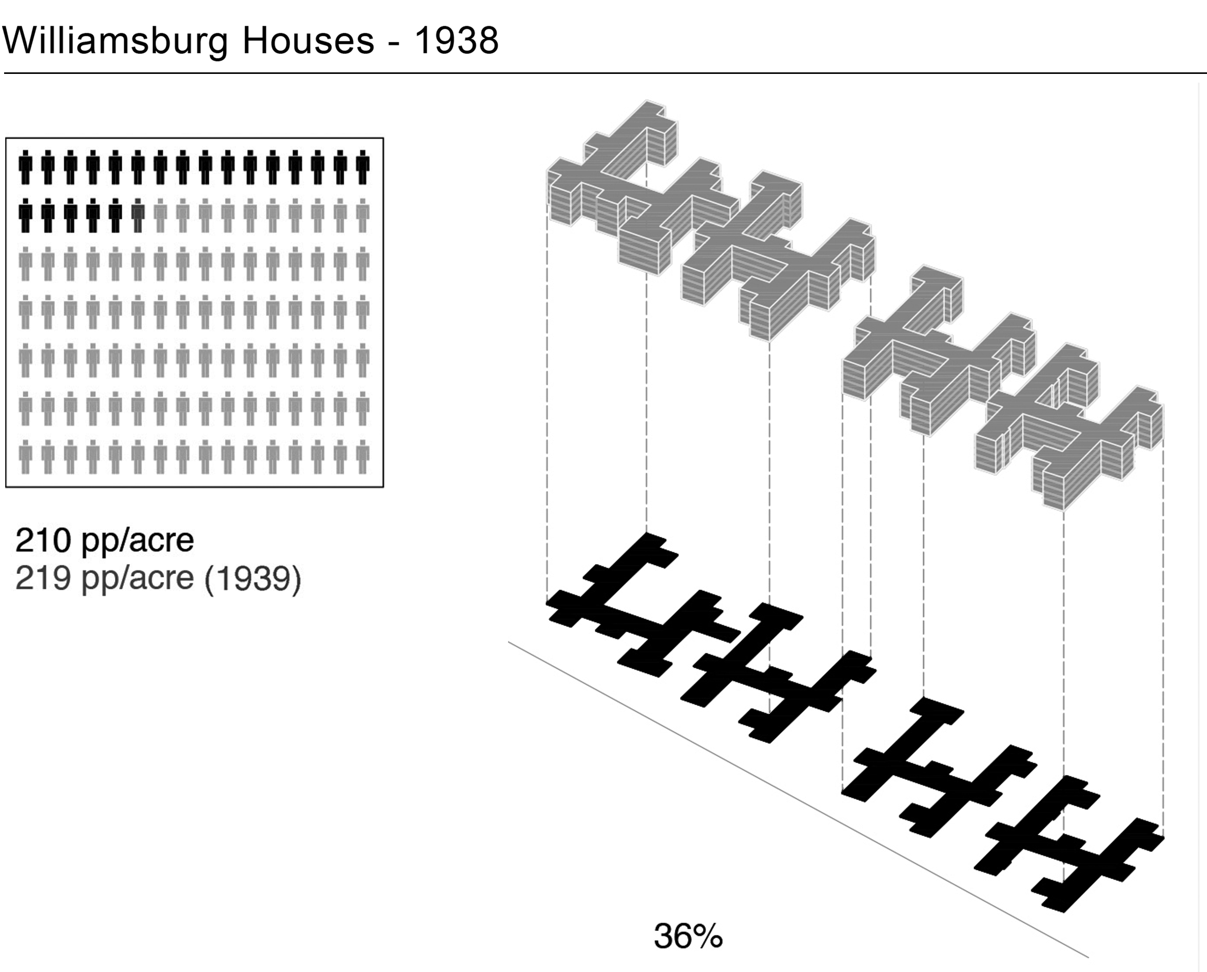
The dreams of New York’s housing reformers – a revolutionary vision of urban living in master-planned, low-density, high-rise apartment communities – were realized in postwar New York. From the 1940s to the 1960s, bulldozers tore down block after block in neighborhoods such as Harlem, Brownsville, and the Lower East Side; in the place of the dense tenement and commercial blocks rose standardized red-brick towers. Some redeveloped blocks were all public housing, while others filled in with subsidized middle-class projects. Yet they all had something in common: the “towers in the park” model.
Postwar NYCHA towers such as those of Manhattanville Houses (20 stories) or Polo Grounds Towers (30 stories) dwarfed pioneering 6-story projects like Queensbridge Houses. Additional height was a result of improved construction technology, but rarely meant greater population or built density. Still in the thrall of a density-reduction strategy, and limited by government funding in the total number of units they could build, administrators created postwar superblocks far larger than was required to guarantee light and air in every apartment. De-mapped streets boosted open space percentages, further isolating buildings from the grid. Car-free pathways, often lined by benches, threaded project grounds and offered shady walks as the canopy of London Plane trees matured. System-wide, by the 1960s towers covered just 18 percent of their sites, which was a point of pride among NYCHA administrators. Yet these superblocks lacked the vitality that stores, services, and restaurants gave to traditional New York neighborhoods.
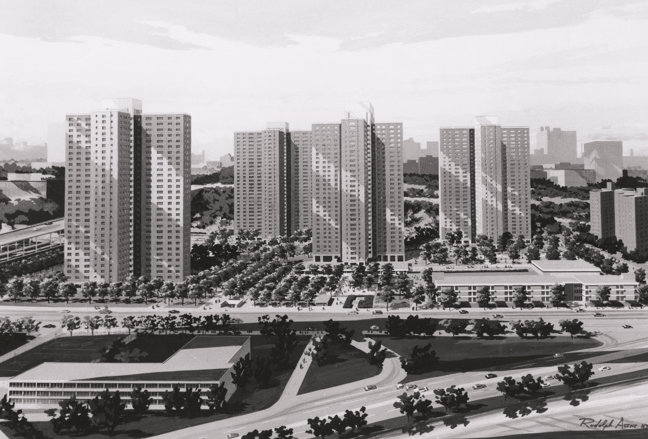
The tower in the park was also the model for Robert Moses’s private-sector and non-profit partners in a variety of state-subsidized housing programs. An early example of postwar middle-income housing was Queensview (1950) in Long Island City. Subsidized by New York State’s Redevelopment Companies Law, and targeted for veteran families, it featured freestanding blocks that maximized sunlight in apartments and open space between towers and abundant parking. The popularity of Queensview encouraged deeper state subsidies. Most of the succeeding developers in middle-income programs, later known as Mitchell Lama, would adopt towers in the park to achieve the density-reduction strategy.
Critics
Jane Jacobs:
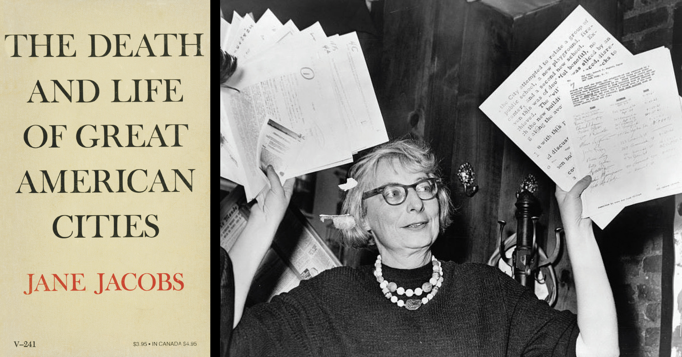
Already by the late 1950s, critics of the “towers in the park” and superblock planning began to publish influential essays that took on the modernist orthodoxies. The most famous of these critics today is Jane Jacobs (1916–2006), who in 1961 published her classic book The Death and Life of Great American Cities. A resident of the West Village and owner of a three-story row house at 555 Hudson, Jacobs became the defender and eloquent evangelist of traditional streets and mixed-use neighborhoods.
In Chapter 11 of Death and Life, “The Need for Concentration,” Jacobs argued against the standardization of buildings and the emphasis on open space in new housing projects. In careful and complex analysis, she recommended a much higher person-per-acre density for vibrant and successful neighborhoods. She was a fierce critic of formulas and called the calculations of “average” density – raw figures of persons per acre – a “statistical monstrosity much used by reformers.” Nevertheless, pushed to quantify, her target ideal density was about 500 pp/acre.
Lawrence Halprin:
Lawrence Halprin (1916–2009), a leading American landscape architect of the postwar era who was born and bred in Brooklyn, but practiced in San Francisco, was invited by the John V. Lindsay administration to consult on ways the city could repair the damage done to the urban and social fabric by sterile, and often dangerous, tower-in-the-park projects. His team’s report, New York, New York; a study of the quality, character, and meaning of open space in urban design, was broad and brilliant, offering ideas as relevant for today as building on the housing projects’ parking lots.
In general, Halprin called for increasing density, both of population and built area, which he maintained would create more vital neighborhoods. Although he was as careful as Jacobs to warn of the difficulty of any analysis of ideal densities, he ventured: “certainly 500-600 persons per acre is acceptable with the new technologies and new methods of achieving amenity.”
Jane Jacobs. The Death and Life of Great American Cities:
High dwelling densities have a bad name in orthodox planning and housing theory. They are supposed to lead to every kind of difficulty and failure.
But in our cities, at least, this supposed correlation between high densities and trouble, or high densities and slums, is simply incorrect, as anyone who troubles to look at real cities can see.
One reason why low city densities conventionally have a good name, unjustified by the facts, and why high city densities have a bad name, equally unjustified, is that high densities of dwellings and overcrowding of dwellings are often confused. High densities mean large numbers of dwellings per acre of land. Overcrowding means too many people in a dwelling for the number of rooms it contains. The census definition of overcrowding is 1.5 persons per room or more. It has nothing to do with the number of dwellings on the land, just as in real life high densities have nothing to do with overcrowding….
Adding further to the confusion came a statistical monstrosity much used by reformers to aid their housing project crusades—a raw figure of numbers of persons per acre.
Nor does slum clearance as practiced in our cities usually have anything to do with solving the problem of overcrowding. Instead, slum clearance and renewal typically add to that problem. When old buildings are replaced with new projects, the dwelling densities are often made lower than they were, so there are fewer dwellings in a district than before. Even if the same dwelling densities are repeated, or lifted a little, fewer people are accommodated than were put out, because the people who were displaced were often overcrowded.
In the city of enough people in enough dwellings, the diversity can be generated and people can develop attachment and loyalty to their unique neighborhood mixture of things…
Overcrowding within dwellings or rooms, in our country, is almost always a symptom of poverty or of being discriminated against, and it is one (but only one) of many infuriating and discouraging liabilities of being very poor or of being victimized by residential discrimination, or both.
What are proper densities for city dwellings?…Just so, proper city dwelling densities are a matter of performance. They cannot be based on abstractions about the quantities of land that ideally should be allotted for so-and-so many people (living in some docile, imaginary society).
Densities are too low, or too high, when they frustrate city diversity instead of abetting it…
… As a general rule, I think 100 dwellings per acre will be found to be too low.
…How high “should” city dwelling densities go? How high can they go?
Obviously, if the object is vital city life, the dwelling densities should go as high as they need to go to stimulate the maximum potential diversity in a district. Why waste a city district’s and a city population’s potential for creating interesting and vigorous city life?
This is fatal, because great diversity in age and typesof buildings has a direct, explicit connection with diversity of population, diversity of enterprises and diversity of scenes.
Popular high-density city areas have considerable variation among their buildings—sometimes immense variation. Greenwich Village is such a place. These averages are obtained from mixtures of everything from single-family houses, houses with flats, tenements and all kinds of small apartment houses and flats, on up to elevator apartments of many different ages and sizes.
The reason Greenwich Village can reconcile such high densities with such great variety is that a high proportion of the land which is devoted to residences (called net residential acres) is covered with buildings. Relatively little is left open and unbuilt upon. In most parts, the buildings cover the residential land at averages estimated as ranging from 60 percent to 80 percent of the land, leaving the other 40 percent to 20 percent of the land unbuilt on as yards, courts and the like. This is a high ratio of ground coverage. It is so efficient a use of the land itself, that it permits a good deal of “inefficiency” in buildings. Most of them need not be highly efficient at packing, but even so, high average densities are reached.
Now, suppose that only 15 percent to 25 percent of the residential land is built upon, and the other 75 percent to 85 percent is left open and unbuilt on. These are common figures for housing projects, with their expanses of open land which are so hard to control in city life and produce so much vacuity and trouble. More open land means remarkably less building space.
If open land is doubled from 40 percent and becomes 80 percent, the amount of land that can be built upon is cut by two thirds! Instead of having 60 percent of the land to build on, you have only 20 percent to build on.
When so much land is left open, the land itself is being used “inefficiently” so far as packing dwellings on it is concerned. The strait jacket is very tight when only 20 percent or 25 percent can be built upon. The density of dwellings must be very low, or, alternatively, dwellings must be packed with great efficiency onto the fraction of the ground that can take the buildings. Under these circumstances, it is impossible to reconcile high densities with variety. Elevator apartments, and often very high ones, are unavoidable.
…. I doubt that it is possible, without drastic standardization, to go higher than the North End’s density of 275 dwellings per net acre. For most districts—lacking the North End’s peculiar and long heritage of different building types—the ultimate danger mark imposing standardization must be considerably lower; I should guess, roughly, that it is apt to hover at about 200 dwellings to the net acre.
… cities need high dwelling densities and high net ground coverages,..
…Systems of thought, no matter how objective they may purport to be, have underlying emotional bases and values. The development of modern city planning and housing reform has been emotionally based on a glum reluctance to accept city concentrations of people as desirable…
No good for cities or for their design, planning, economics or people, can come of the emotional assumption that dense city populations are, per se, undesirable. In my view, they are an asset. The task is to promote the city life of city people, housed, let us hope, in concentrations both dense enough and diverse enough to offer them a decent chance at developing city life.
Housing Reforms Zoning


Left: Setback diagrams showing the bulk limitations in the 1916 Zoning Resolution. Final report, June 2, 1916. Commission on Building Districts and Restrictions, Board of Estimate, New York, 258-9. Right: 1929 Multiple Dwelling Law.
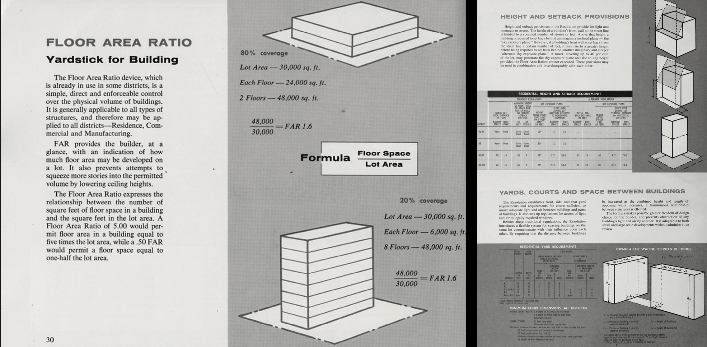
Today, zoning regulates all development across the city. What emerges from the history of housing recounted in this exhibition, however, is that, until 1961, zoning in fact had very little effect on the forms of residential architecture or public housing. The change to the formulas that so powerfully affect the city today is the result of the zoning revisions of 1961, which were shaped by the work of housing reformers of the 1930s who emphasized low density and open space and created the all-important new concept of Floor Area Ratio (FAR). The mechanism of FAR changed the previous system of a cap on height for residential buildings to a cap on floor area – i.e., a maximum buildable area in square feet, based on a multiple of the area of the lot.
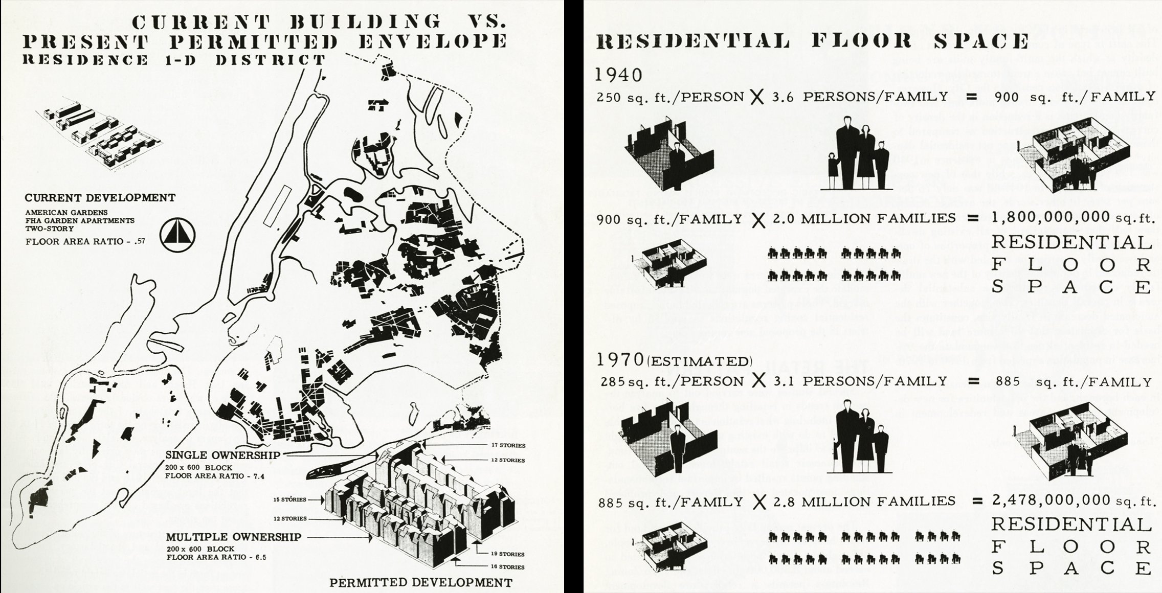
Where did the concept of FAR originate? It is astonishing that the answer to this question, so determinative for the city’s built environment for more than half a century, has been so obscure. Although the idea existed in several precedents in the early 1930s, the specific lineage seems to lie in the work of Frederick L. Ackerman (1878-1950), the head of the Technical Division of NYCHA and his young deputy William Ballard (1905-1993). In 1934, the two authored a little known NYCHA study titled “The Population of New York City as Permitted by the Zoning and Multiple Dwelling Laws.” Their report was the first to explore – indeed to obsessively calculate – the total buildable area of both full blocks and of the city as a whole allowed under the 1916 zoning. Translating that volume (“bulk”) into floor area, and estimating the average floor space needed per person for work and for housing, they concluded that the city could accommodate more than 76 million people. That excessive number proved to them the need for reform.
Sixteen years later, in 1950, working as a consultant to the New York City Planning Commission, Ballard produced the Plan for Rezoning the City of New York. This major study outlined most of the revisions eventually incorporated in the 1961 law, including the citywide application of FAR formulas and an increase in open-space requirements for residential buildings. The drumbeat of the report, prepared by his firm Harrison, Ballard & Allen, argued that the 1916 zoning law allowed far too much built density. As in the earlier NYCHA study, Ballard keyed the buildable floor area to projections of future population and made specific recommendations for FAR limits.
As implemented in 1961, the reforms of the new law dramatically reduced the total amount of built density allowed citywide on both commercial and residential land, cutting the hypothetical total developable area of the city by more than three quarters. In addition, the new code’s low lot-coverage standards, including “tower in the park” zones, mandated that private developers build under guidelines formerly applied to subsidized housing only. Ballard became Chairman of the City Planning Commission from 1963 to 1966, overseeing the rules he helped to frame.
In the years that followed, though, the 1961 law collected critics among private developers, who complained the new rules made building uneconomic. This problem was addressed by a revision of the code in 1987 that introduced contextual zoning, a part of the Quality Housing Program. The QHP’s allowance, in certain districts, for additional FAR for new buildings that blended in with older ones (covering a higher percentage of lots, etc.) was a repudiation of the housing reform ethos that had prioritized open space over density and neighborhood context since the 1930s.